Kamloops
accessibility map
TRU Intro to Sociology II Community Project
Kamloops Accessibility Map is a collective community engagement project by Introduction to Sociology II students at Thompson Rivers University. We explore different neighbourhoods in Kamloops and document visible & invisible barriers that prevent the full participation of Kamloops community members and a universal accessibility design that supports all members of your community. Based on the insights from the social model of disability, which emphasizes the role of societal factors in disabling people with disabilities. We aim to document both hostile design and universal design in Kamloops and explore solutions to create accessible environments for all members of Kamloops.
Land Acknowledgement
Thompson Rivers University campus is on the traditional lands of the Tk’emlúps te Secwépemc within Secwepemcúl’ecw, the traditional and never-surrended territory of the Secwépemc. We deeply appreciate the opportunity to study, learn and work on these Indigenous lands and are fully committed to learning “what the land as a system for reciprocal relations and obligations can teach us about living our lives in relation to one another and the natural world in non-dominating and nonexploitative terms” as a Yellowknives Dene Indigenous scholar, Glen Coulthard, points out in his book <Red Skin White Mask: Rejecting the colonial politics of recognition>. We hope this accessibility project contributes to creating public awareness of how specific designs of the city structurally exclude some members of the community, in particular, members from marginalized communities, and thus we put a collective effort to provide inclusive spaces for everyone.
Map
Below is a map of all submissions. Click on a map pin for more information about that location.
hostile architecture
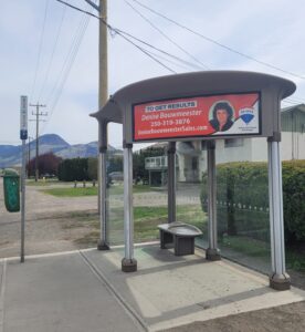
Hostile Bus Stop
Parkcrest Ave at Singh Street Northbound
This hostile bus stop is located on Parkcrest ave at Singh Street in Brocklehurst. This street is well known for drivers speeding well above the spee…
Read more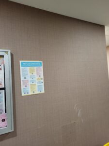
Safety beyond what we see
1025 University Drive, Kamloops, British Columbia
This image helps people to see what material we can you use to help students with unseen disabilities such as epilepsy or fainting spells.
Read more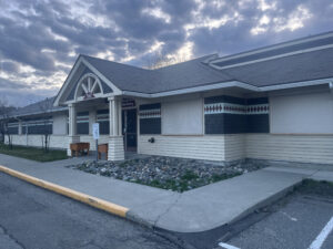
Little Fawn Nursery-Hostile Design
360 Chief Alex Thomas Way, Kamloops, BC V2H 1H1
This image shows the Little Fawn Nursery building located on 360 Chief Alex Thomas Way. Photo taken March 29, 2025. This image depicts the Lit…
Read more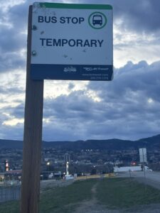
Sun Rivers Bus Stop-Hostile Design
Shuswap at Chief Alex Thomas, Kamloops, BC V2H 1H1
This image shows a Sun Rivers bus stop, located on Chief Alex Thomas Road. Photo taken March 29, 2025. This image depicts one of three Sun Rivers bus…
Read more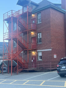
Residential School Building-Hostile Design
330 Chief Alex Thomas Way, Kamloops, BC, V2H 1H1
This image shows the exterior of the Residential School building, located at 330 Chief Alex Thomas Way. Photo taken March 29, 2025. This image…
Read more
Distance from North tower to Main Parking lot
1025 University Drive North, Kamloops, BC
Figure 1.2 – This image depicts the distance from the North Tower entrance to the beginning of parking lot N. Image source: https://earth.google.com/w…
Read more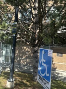
Parking for people with disability In front of North Tower
1025 University Drive North, Kamloops, BC
Figure 1.1 – Handicap parking spot outside North Tower. Photo taken: March 29, 2025. Taken at 1025 University Dr. N. This is a photo showing the signs…
Read more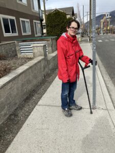
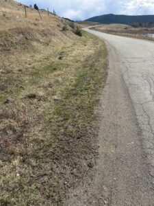
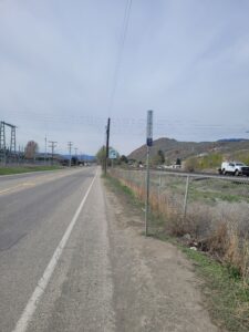
Lack of Sidewalks on Mt. Lolo Road
Mt. Lolo Road
This photo was taken on Mt. Lolo Road at 2:18 PM on the 29th of March. It showcases an invisible barrier in the area: the lack of dedicated sidewalks….
Read more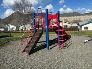
Inaccessible playground
7545 Dallas Drive
This photo was taken at 7545 Dallas Drive on March 30, 2025. The image shows the community playground, located atop a slight hill. Because of this, it…
Read moreWhere I live!
1025 University Drive
These are both of my designs for my location of choice.
Read more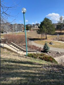
Stair Access To Pineview Valley Park
Pineview Valley Park, Kamloops, BC, 50.6533507, -120.3994489
Certain areas of the Pineview Park require stair access, however there is no ramp/accessible option. The grass and hills can be tricky to navigate in…
Read more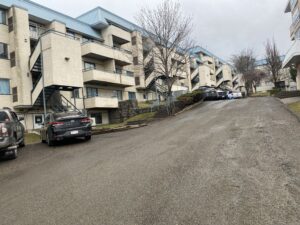
East Village Hostile and Universal Designs
705 McGill Rd Kamloops BC V2C 6N7
Stairs leading to all the residency rooms and steep incline leading up to more residencies, laundry room, and common area. Photo taken: March 2…
Read more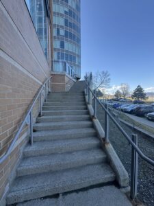
NT
1025 University Dr, Kamloops, BC
The hostile designs that are located in North Tower are the back entrances from the parking lot. It’s a hostile design because it does not provide a p…
Read more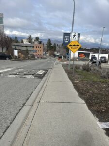
McGill’s Infamous Hill
McGill Rd, Kamloops, BC V2C 6N2 50.668694, -120.364357 850
This photo shows the infamous hill leading down to TRU or heading up to McGill. This hill proves a difficult challenge for people without disabilities…
Read more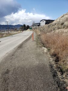
Shushwap Road, after the roundabout
Shuswap Rd, Kamloops, BC, 50°40’59.8″N 120°17’36.8″W
Shuswap Road has accessibility issues. From the roundabout onwards, there are no sidewalks, so there is not enough walkable space for even able-bodied…
Read more
Riverside Stair Bridge Railway Crossing
95 Third Ave Kamloops BC V2C 1Y1 Canada 50.67678° N, 120.33443° W
This railway crossing is an example of Hostile Architecture in Downtown Kamloops. As seen in the photo, the stairs are quite tall. Not pictured is the…
Read moreUniversal Design
Universal Bus Stop
Parkcrest Ave at Singh Street Southbound
This is the bus stop at Parkcrest Ave and Singh Street southbound, this is a very safe and universal design. Accessible for all.
Read more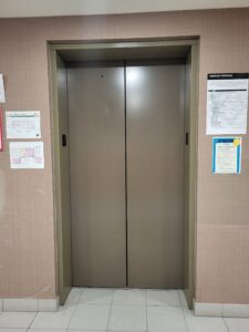
Beyond what we see
1025 University Drive, Kamloops, British Columbia
This picture depicts an elevator which helps people who are visually or physically impaired as it includes brail on the buttons.
Read more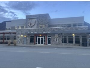
All Nations Trust Company- Universal Design
520 Chief Eli Larue WAy, Kamloops, BC, V2H 1H1
This building is an excellent example of Universal Design. The architectural design was made to allow people of all physical abilities to use and acce…
Read more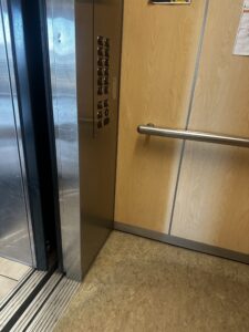
North Tower Elevators
1025 University Drive North, Kamloops, BC
Figure 2.1 – This image shows the interior of an elevator in North Tower. Photo taken: March 29, 2025. Taken at 1025 University Dr. N. This is a photo…
Read more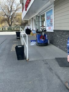
Accessible Ramp
6221 Barnhartvale Rd, Kamloops, BC V2C 6V6
At the nearest convenience store to my house, there is an accessibility ramp. The ramp has a railing to help with stability, a gradual incline, and is…
Read more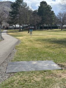
Westsyde Centennial Park Accessible Disc Golf Course
705 Franklin Rd, Kamloops, BC V2B 0E6, 50.7496204° N, -120.3504851° W
The above photo was taken at 1:12 PM on March 29. This photo shows one of several tees at the Westsyde Centennial Park’s accessible golf course. The c…
Read more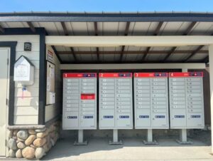
Accessible Mailboxes
7805 Dallas Drive
This photo was taken on March 29, 2025. Depicted in the image are four mailboxes located at 7805 Dallas Drive. While only being around four and a half…
Read moreWhere I live!
1025 University Drive
These are both of my designs for my location of choice.
Read more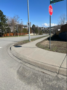
Curb Cuts in Pineview
Lodgepole Dr. and Hugh Allen Drive, Kamloops, BC, 50.6539091, -120.403320
Cut outs in curbs allow for anyone in a wheelchair, or anyone using wheels to have an easier time accessing the sidewalk. In crosswalks, they allow fo…
Read more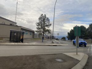
East Village Hostile and Universal Designs
705 McGill Rd Kamloops BC V2C 6N7
Bus stop outside East Village entrance. Photo taken: March 28th, 2025. Taken at 705 McGill Rd. This is a photo showing the bus stop with a bench at th…
Read more
Accessible Entrances at North Tower
1025 University Dr, N Kamloops British Columbia V2C 0E1
The front entrances to North Tower are accessible for everyone, and it even has an accessible way to open the doors. And the elevators are also a univ…
Read more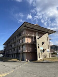
McGill’s Limited Accessibility
McGill Rd, Kamloops, BC V2C 6N2 50.668724, -120.364161 850
The only universal design comes from the basement levels of each building; the rest of the stories are then inaccessible due to steep cement stairs. C…
Read more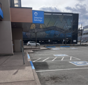
Interior Savings Building Parking and Entrance
350 Lansdowne St Kamloops BC V2C 1Y1 Canada 50.67697° N, 120.33314° W
As pictured, this is the parking lot in front of Interior Savings, located in Downtown Kamloops. This is a prime example of universal design. There ar…
Read more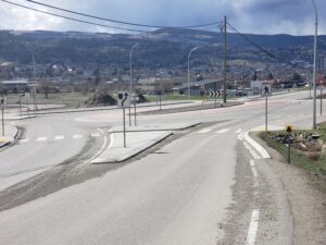
Shushwap Road Roundabout
Shuswap Rd, Kamloops, BC, 50°40’59.8″N 120°17’36.8″W
This roundabout crosswalk supports universal design, due to its crosswalks encouraging accessibility to those visually impaired by providing those wit…
Read more